
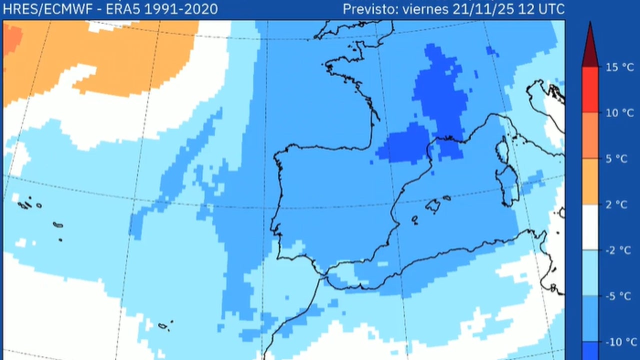
The winter episode that began this Wednesday with the entry of an air mass of Arctic origin will last until next Saturday and will leave snowfall on “important” roads in the north of the peninsula, as reported by the State Meteorological Agency (AEMET). Night frosts will extend across much of the interior and daytime temperatures will be more typical of the coldest days of winter than the end of autumn.
The emergence of this very cold air will cause copious snowfall at very low altitudes, between 300 and 400 meters, which will affect not only mountain systems, but also cities and roads in Castilla y León, Navarra, La Rioja and Cantabrian communities.
As explained by Rubén Del Campo, spokesperson for the AEMET, temperatures will be between “5 and 10 degrees below normal” for the time. The coldest morning will be Saturday with values that will not exceed 2-5 degrees below zero in many areas of the country.
Snowfall since this Wednesday
The passage of a front is already going to leave rainfall this Wednesday in northern Galicia, Cantabrian communities, Navarra, La Rioja, northern Burgos and other northern areas, which will be abundant and They will turn into snow in the mountains, with a level that will drop to 800 meters. In the rest of the country, the environment will be stable but noticeably colder. In the Mediterranean it will be close to 20 degrees, while in much of the interior of the northern half it will not reach 10 degrees.
Thursday: snow in cities and roads
The thermal decline will continue on Thursday, with frost in large areas of the north, center and east of the peninsula. Maximum temperatures will barely exceed 10–12 degrees inside. Del Campo predicts “copious snowfall” for this day in the Cantabrian mountain range, north of the Iberian system and the Pyrenees. The level will drop to 500 meters, leaving snow in low areas of Asturias, Cantabria, the Basque Country, Castilla y León, Navarra, La Rioja and the north of Aragón. These snowfalls could affect key communication routes, so extreme caution is recommended
Friday: snow level at 300 meters
On Friday, abundant snowfall will continue in the: Cantabrian area, Pyrenees, northern Castilla y León, Navarra and La Rioja, with an elevation between 300–400 meters. Cities like Pamplona or Vitoria could dawn white. Snow will also be recorded in the central and eastern mountains, as well as in mountainous areas of the Balearic Islands. In addition, there will be rain in the north of Galicia, Cantabrian coastal areas and in the Balearic archipelago. Temperatures will remain very low, between 5 and 10 degrees below normal, with intense frosts in the interior.
Saturday: the coldest morning of the episode
Saturday will dawn with widespread frost in the northern half. It will probably be “the coldest morning of the winter episode”, with values between 2 and 5 degrees below zero in many areas. Throughout the day, the arrival of a milder Atlantic front will begin to soften daytime temperatures and raise the snow level from 700 meters to around 1,400 meters in the afternoon. The rainfall will affect Galicia, Cantabrian communities, Navarra, La Rioja and Castilla y León, and some showers are not ruled out in the Balearic Islands.
On Sunday, temperate and humid air will continue to enter from the Atlantic, with rain in Galicia, Cantabrian communities, the Pyrenees and mountainous areas of the north. It will only snow in high mountain areas and temperatures will rise significantly, recovering values more typical of the time of year.