
After a start to the week marked by gusts of hurricane-force wind, stormy showers and high temperatures in the Canary Islands due to Storm Dorothea, important changes are coming to the Peninsula. The current stability will give way to an episode of rain, snowfall and thermal ups and downs, as Samuel Biener, Meteored expert, warns in his forecast for the coming days. At the end of the week, the arrival of a DANA could further complicate the situation in some areas of the country.
This Tuesday the stable weather will continue in much of Spain, although fog will be the protagonists in the interior and on the northern plateau. Only An Atlantic front will manage to leave some weak rains in Galicia, Asturias and the Cantabrian Mountains. In the Canary Islands, the haze will continue to be the protagonist, with very high dust concentrations. Temperatures will rise in most regions. In cities like Seville, thermometers could reach 20 ºC.
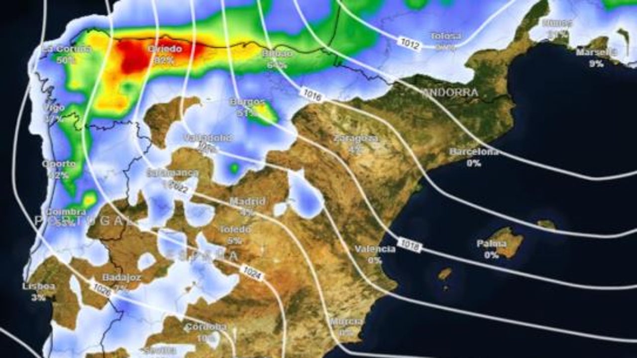
Widespread rain, snowfall in the north and heat in the Mediterranean
The arrival of an Atlantic storm, with associated fronts, will change the panorama between Wednesday and Thursday, according to Meteored forecasts, The rains will spread across a large part of the country, being intense in Galicia, the Cantabrian slope, Navarra, the north of the Central System and the northeast of Castilla-La Mancha. In the south, some scattered showers accompanied by mud are also expected.
Despite the arrival of the storm, Very high temperatures are expected in the Mediterranean due to westerly windsand. These winds, after descending from the peninsular mountain systems, reach the eastern and southeastern coasts overheated, shooting up temperatures and plummeting humidity. This will cause cities such as Alicante, Murcia or Valencia to exceed 23ºC, an unusual value for these dates. In the Cantabrian Sea they will touch 20 ºC.
On Thursday, temperatures will drop in most of the territories, except in the south and on the Mediterranean coast, where thermometers could shoot above 25 ºC, especially in Almería, Alicante and Murcia. That day, with the arrival of cold air, the snow level will drop sharply to 1000 meters in the northern mountain rangeswith more significant snowfalls in the Pyrenees and the Cantabrian Mountains.
A DANA for the weekend?
Facing the Friday, time will stabilize, with a generalized drop in temperatures that will also reach the south and the Mediterranean coast. The rains on the eastern Cantabrian slope and in the Pyrenees will begin to subside, although the snow will continue to fall below 1000 meters.
That same day a DANA could be taken down in the southwest of the peninsula. Throughout the weekend the depression would move towards the Canary Islands, where it would leave heavy showers and storms, as well as snowfall on the summits. On the Peninsula, the situation will also be unstable, with showers in the Strait area and a frontal system that will increase cloudiness in Galicia, the Cantabrian slope and the northern face of the Pyrenees. These precipitations will be in the form of snow in the mountain ranges.