
DANA will mark the start of the week with showers and storms in large areas of the country, accompanied by stifling heat of up to 40 degrees in the southwest. According to the eltiempo.es forecast, the pocket of cold air will be reabsorbed starting Wednesday by a atlantic troughto. This meteorological change will reinforce instability in the north and cause a sharp drop in temperatures starting Thursday.
The episode of instability that affected a good part of the country during the weekend will continue during the first days of the week. The DANA will progressively withdraw towards the southwest, although its proximity will continue to favor the formation of showers and storms in different areas.
DANA will leave showers and storms during the first days
This Monday, the DANA It will be located between the Gulf of Cádiz and the Canary Islands, although its influence will still reach the Peninsula. According to eltiempo.es, they are expected showers and storms in parts of the southwest, especially in Andalusia, Extremadura and Castilla-La Mancha.
In the mountain areas of these communities, the storms could be more intense and accompanied by hail and strong gusts of wind. They are also planned showers in the south of Aragon, the Cantabrian mountain range and the Pyrenees.
Tuesday will be a somewhat more stable day, although they could still produceand isolated storms in the Pyrenees and the Iberian system.
The situation will change again on Wednesday. The DANA will approach the Peninsula again and will be reabsorbed by a trough from the Atlanticwhich will cause a new resurgence of instability.
Storms may appear during the afternoon in the interior of Galicia, the Cantabrian coast, the eastern interior of Andalusia, Murcia, the south and east of Castilla-La Mancha, the Iberian system and the Pyrenees. In some areas they could be strong, with hail and very strong gusts of windaccording to the forecast of eltiempo.es.
The trough will bring more instability from Thursday
Starting Thursday, it will be trough that will absorb the DANA the one that takes center stage. Its advance from the northwest of the peninsula will favor an unstable day, with showers and storms that could be locally strong in much of the northern half.
The most affected areas will be Galicia, Asturias, Cantabria and the north of Castilla y León. They are also expected Precipitation in the center, south and east of the Peninsulaalthough in principle they will be less intense, without ruling out storms in the Balearic Islands.
On Friday, the most important rainfall will be concentrated in the northern thirdespecially in the Cantabrian Sea. They could be locally intense in Cantabria and the Basque Country during the morning and, in the afternoon, in the Pyrenees, the Iberian system and Catalonia.
According to eltiempo.es, the trough could maintain instability for a good part of the week, with especially frequent rains and storms in the northern third of Spain.
From extreme heat to a drop of up to 10 degrees
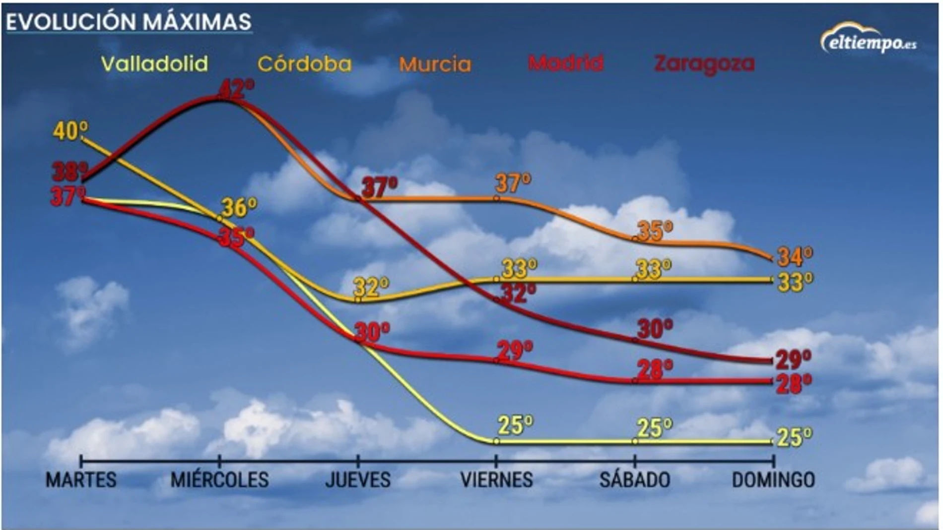
The evolution of the DANA and the trough will also cause a marked thermal swing. High temperatures will continue until Wednesday, with values above 35 degrees in large areas of the interior of the peninsula and the Balearic Islands.
This Monday and Tuesday, the thermometers will be around 40 degrees in the southwest, especially in the valleys of Extremadura, Andalusia and southern Galicia.
On Wednesday, the heat will begin to subside in the west, while temperatures will rise in the Mediterranean area. In Murcia, the interior of the Valencian Community, Catalonia and the lower and middle Ebro could reach between 38 and 40 degrees.
The most pronounced change will come from Thursday. The temperatures will decrease noticeably and generally, giving way to a much softer atmosphere during the second half of the week.
In some areas of the interior of the northern peninsula, the maximums could be between 5 and 10 degrees below usual for these dates. Night temperatures will also drop and the nights will be cooler, although in the Mediterranean there could still be minimum temperatures of between 20 and 25 degrees.