
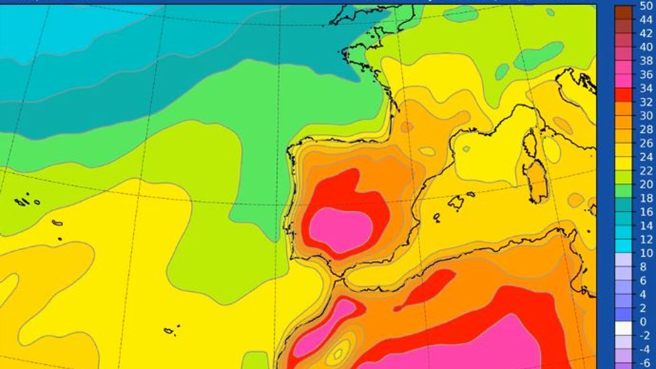
Spain will live this week an exceptional heat episode, with temperatures that could reach or even exceed 40 degrees in some areas of the Southwest Peninsularas Rubén del Campo, spokesman for the State Meteorology Agency (Aemet) reported
The thermometers will mark values between 5 and 10 degrees above normal, and even up to 15 degrees in some regionsleaving a most proper summer atmosphere than mid -September. Night temperatures will also be high for the time. Tropical nights are planned on the Mediterranean coast, central and south of the country.
As for the rains they will be scarce and will be limited to the peninsular north, although storms will also form, some of them locally strong, in areas of the Pyrenees, Catalonia and in points of the east peninsular and the environment of the Iberian system.
Storms in the Northeast
This Tuesday, the skies clear in much of the country will predominate, except in the peninsular northeastern, where the Aemet expected Locally strong storms in Pyrenees and Catalonia, and that could be accompanied by hail and intense wind gusts.
In the Cantabrian and in the Strait, drizzles are expected. In the Canary Islands, where there will be Calima in significant concentrationshigh cloud intervals are foreseen in the western islands.
In maximum temperatures they will continue to rise, especially in Galicia, Western Cantabrian and the Canary Islands. Se will reach or exceed 34 to 36 degrees in large part of the central and southern peninsularand the 38 degrees in the valleys of the Guadiana and the Guadalquivir.
Thursday: the heat peak
On Wednesday and Thursday they will be marked days by a “full summer atmosphere”, with hardly any rains and with temperatures that will continue to rise, especially in the northwith values between 10 and 15 degrees above the average in some areas.
In large areas of the country, 34 to 36 degrees will be exceeded, and in the valleys of the Tajo, Guadiana and Guadalquivir they will register between 38 and 40 degrees. It is not ruled out that on Thursday the 40 degrees are exceeded in points of the Guadalquivir Valley; The nights will also be very warm, with minimal that will not fall from the 20 degrees on the Mediterranean coast and in areas of the central and southern peninsular.
Cities like bAdajoz, Córdoba, Sevilla, Jaén, Ciudad Real or Toledo could touch the 40 ° Cadvances eltiempo.es. Values of Up to 35 ° C in Madrid, Zaragoza, Valladolid or Logroño. Even in usually cooler areas such as the Cantabrian, 30 ° C could be exceeded, especially in its eastern part. In the rest of the north, temperatures will range between 24 and 26 ° C.
When will temperatures lower?
Rubén del Campo has indicated that the forecast for these days has uncertainty, and although in principle on Friday the temperatures would remain high. From the weekend they would begin to descend. However, it is still to be determined “the magnitude and extension of that descent.”
For its part, Eltiempo.es indicates that the entrance of a VAtlantic Aguada will bring colder air and possible rainfall, causing a generalized thermal descent. On Sunday, this cooling will be more pronounced in the western half of the country, ending an episode marked by anomalously high temperatures.