
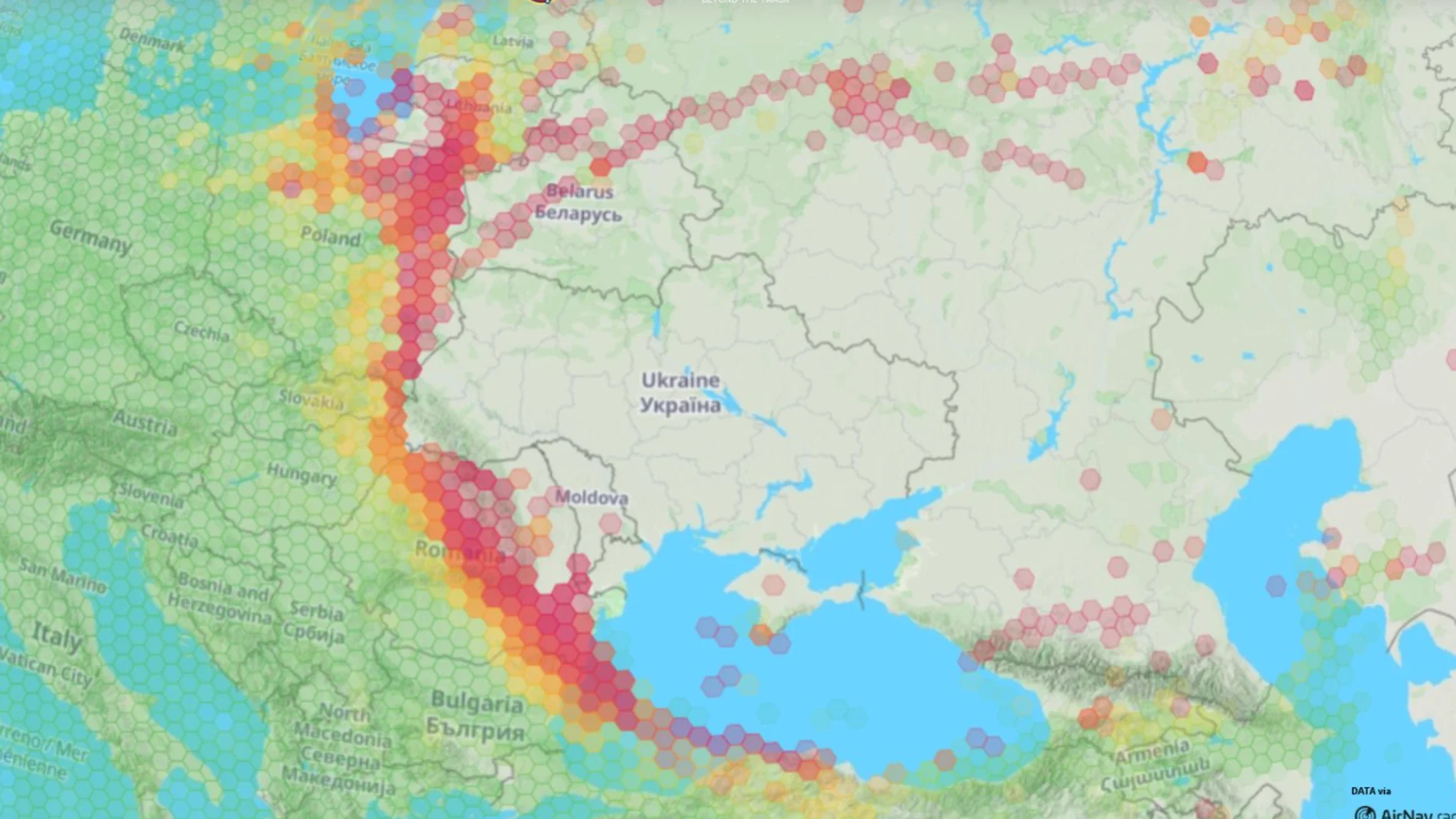
GPS has a weakness that is rarely perceived when the position of an airplane appears on a screen: its signals come from satellites located more than 20,000 kilometers away and are extraordinarily weak when they reach the Earth’s surface. This characteristic makes them an indispensable navigation tool, but also a vulnerable target. On November 3, a large swath of NATO’s eastern flank experienced interference that made it difficult to receive satellite navigation signals. The phenomenon spread, according to data collected by the Italian ItaMilRadar project, from the south of the Baltic Sea to the vicinity of the Black Sea.
The areas with the highest concentration of disturbances appear near the Russian exclave of Kaliningrad, in eastern Poland, along the borders of Belarus and Ukraine, and in areas of Romania, Moldova and Bulgaria. The geographical continuity of the strip is striking, but does not amount to a widespread blackout of Alliance navigation systems. So far no government has officially claimed responsibility for the interference, although the proximity of several affected areas to Russia and Belarus, as well as their coincidence with areas related to the war in Ukraine, fuel hypotheses about the use of electronic warfare systems. But geography, by itself, is not proof of authorship.
One of the possibilities raised is that part of the disturbances come from Russian systems designed to hinder the navigation of drones that attack Ukrainian territory. The interference could also be related to anti-drone teams deployed by NATO countries to protect their airspace. These systems can blocking navigation signals with the purpose of preventing an unmanned device from reaching its objective, although its emissions can also affect other nearby receptors. There is, for now, no confirmation that any of these explanations are responsible for the episode.
The difference between the two main forms of interference is essential. He jamming consists of emitting a radio signal that interferes with the reception of the authentic satellite signal. The receiver may fail to obtain a reliable position or lose the signal altogether. He spoofingon the other hand, is more misleading: the system receives false signals that imitate legitimate ones and can calculate an incorrect position or time without immediately realizing that it is being manipulated. The European Union Aviation Safety Agency (EASA) warns that both phenomena have intensified since February 2022, especially around the Baltic Sea, the Black Sea, the Mediterranean and other regions close to conflict zones. NATO has already warned of the growing impact of these disruptions on civil aviation. In May 2025, the Alliance noted that deliberately blocking signals and issuing false signals could lead to delays, rerouting, and even cancellations of takeoffs and landings.
With all this in mind, Itamilradar points out that the Beech King Air 350ER SPYDR of the Italian Air Force (registration MM62300 – callsign IAM1498) “has been operating from Pantelleria for the last two days, which marks its return to the central Mediterranean after a prolonged absence in the region,” notes Itamilradar. This aircraft is a military version of the King Air 350ER twin-turboprop aircraft, configured for Intelligence, Surveillance and Reconnaissance (ISR) missions, as well as SIGINT/COMINT (signals and communications intelligence). During the last two months the SPYDR would have been deployed in Lithuania and in the Baltic region in general, where it carried out signals intelligence (SIGINT) missions. Therefore, its arrival in the Mediterranean could have to do with increasing monitoring and control activities of GPS signals.
In a scenario where drones, aircraft and military systems increasingly depend on satellite navigation, the ability to operate when that signal disappears or is no longer reliable becomes a security issue. GPS remains a fundamental tool, but the incident reminds us that, in the electronic warfare environment, knowing coordinates does not always mean being able to trust them.